The Spouting Horn is at the end of the road in Poipu. It is close by and I have gone there many times in different light to photograph it. When the waves come in under a lava shelf they force water up through a hole in the shelf. In addition there are several smaller holes where air rushing out make strange moaning sounds. The large hole in the same lava shelf shown in the lower photo was once a blow hole that sent a seaplume 200 feet high. In the 1920's the local sugar company manager had his worker drop explosives in it to widen it because the salt spray was stunting sugar cane in the nearby field.
Tuesday, August 27, 2013
Spouting Horn
The Spouting Horn is at the end of the road in Poipu. It is close by and I have gone there many times in different light to photograph it. When the waves come in under a lava shelf they force water up through a hole in the shelf. In addition there are several smaller holes where air rushing out make strange moaning sounds. The large hole in the same lava shelf shown in the lower photo was once a blow hole that sent a seaplume 200 feet high. In the 1920's the local sugar company manager had his worker drop explosives in it to widen it because the salt spray was stunting sugar cane in the nearby field.
Monday, August 26, 2013
Glass Beach
Glass Beach is the site of and old dump and broken glass that has been tumbled by the surf washes up on the beach. The dump was also used to dispose of machinery and car parts from the nearby industrial area. Decades of ocean waves have beat these pieces on the lava shoreline making some interesting rusting still lifes. The lava ledge they rest on is accessible at low tide.
Sunday, August 25, 2013
Black Sand Beach
There are several beaches that have black sand (actually dirt with a good publicist). They are black because of the pulverized black lava. This beach is at the mouth of the river and is composed of sediment carried down the river. At the mouth of the river it builds up a sandbar and when waves break over the bar they sink into the porous sand fast and the white foam at the leading edge makes for interesting graphics and and great place to photo models with the white water and black sand.
Tuesday, August 20, 2013
Monday, August 19, 2013
Mount Wai'ale'ale
Mount Wai'ale'ale with over 440 inches of rain a year is said to be the wettest spot on earth. There are no roads to the top but there is a very muddy 4WD road through a lush green valley that ends at the river in the top photo. From here there is a hike to some waterfalls. Continuing on to the top involves scaling some waterfalls but will stop you when you come to a 3000 foot fall at the back of the crater.
Saturday, August 17, 2013
Hanalie Lookout
The Hanalie lookout has a great view of the Hanalie River and the valley where much of the Taro grown in Hawaii comes from. The Taro root is pounded to make poi, a staple in the local diet.
The top photo is a panorama made from 9 shots.
Friday, August 16, 2013
Monk Seal
The monk Seal is on the endangered list as there are thought to be only 1000 left. When one comes up to rest on the beach the authorities will fence it off to keep it from being harassed. This one on the beach this morning outside the condo. It started to rain, actually only a mist, when I went out to photograph it. The rainbow shot is a panorama made from two photos.
Thursday, August 15, 2013
Cave near Poipu
Along a small stream between Poipu and the beaches at Maha'ulepu is a cave. Most of the roof has fallen in now but when I was here over 20 years ago it only had a small hole to let in light and there was a large banyan tree growing in it. The only entrance was through a triangular hole about three feet high along the stream bed. I carried my 4x5 film camera in and what light was coming in I made a photo of the Banyan that took a 24 minute exposure and is one of my favorite photos. A week later Hurricane Iniki hit Kauai and the storm surge and wind destroyed the tree along with the roof of the cave. Recent excavation in the cave have reveled artifacts from all stages of human occupation of the island.
Wednesday, August 14, 2013
Maha'ulepu at Sunrise
The beaches at Mala'ulepu are down a rough dirt road and make a great place to photograph models in early morning light. No, no photos from the model shoots, maybe later on another blog.
Tuesday, August 13, 2013
Tree Tunnel
In the early 1900's a local land owner planted over 500 trees along the road that goes south of the highway to Koloa and Poipu. This has always been called the Tunnel of Trees. Hurricane Iniki in 1992 did a lot of damage to the tunnel and the trees don't intertwine at the top as much as they did before.
Monday, August 12, 2013
Cemetery on South Shore
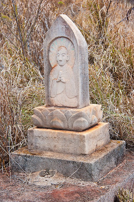
While exploring the south coast found this cemetery down a dirt road. It was on a cliff at the waters edge and only a few of the graves were recently attended. Most were hidden in dry brush. The oldest dates I saw were the early 1900's.
Sunday, August 11, 2013
Cactus Flowers
There are a lot of cactus growing along the ocean road and every morning on my walk there are a couple blossoms. These cactus blossom at night and at sunrise they are starting to close. Each blossom lasts only one night. Then the other morning there were over a hundred blossoms in the first block and even though they were starting to close I had to get the camera and photograph a few. The next morning I only saw two blossoms on my entire walk.
Saturday, August 10, 2013
Waimea Canyon
Several views of Waimea Canyon including this last one that shows the ocean off to the left. The panorama photo at the top was made from 12 separate photos and has a lot more detail that a computer screen will show.
Friday, August 9, 2013
Thursday, August 8, 2013
Wednesday, August 7, 2013
Flossie, What kind of name is that?
Tuesday, August 6, 2013
 |
| Tiger 6 |
 |
| Push |
 |
| To the next island |
 |
| In port |
Got to go out in a friends tug boat as he helped a cruise boat out of the harbor. The tug was awesome, two V16 Cat engines for a total of 5000HP and a great drive system that can rotate the tug on its center line and in addition to forward and reverse can go sideways. What a ride. Thanks Miguel.
Monday, August 5, 2013
Polihale
This is the end of the road on the west side of the island. The cliffs ahead are the start of the Na Pali cost. From here it is 16 miles to Kee Beach on the north side of the island. It is possible to kayak from Kee beach to this point but it is not an easy trip. You can also walk to the left for 17 miles on this deserted beach to the next town. No, I didn't do that either.
Sunday, August 4, 2013
Waimea Canyon
At ten miles long and 3,600 feet deep Waimea Canyon has been called the Grand Canyon of Hawaii. In fact it was Mark Twain that called it that even though he never saw it himself. Sorry Mark, I know the Grand Canyon and this isn't it. The combination of red soil and green vegetation does, however, make for great views. The mountain across the canyon, with over 440 inches of rain a year, is the wettest spot on earth and accounts for all the vegetation and the fact that at the top on the canyons you are usually in the clouds.
Saturday, August 3, 2013
Kauai, Hawaii
After several summers photographing at over 10,000 feet in the mountains of Colorado this summer decided to try Hawaii. It's been over ten years since I have been here. In fact that trip was all done with a 4x5 view camera and some of my favorite photos were done here.
This is the view from the living room and patio, also from the window of the large shower. Next to the condo is a several acre Hawaiian Ancient site and the ocean is across the road coming right up to the road at high tide. This cove is a great place to snorkel, lots of fish and always a couple turtles.
This is the view from the living room and patio, also from the window of the large shower. Next to the condo is a several acre Hawaiian Ancient site and the ocean is across the road coming right up to the road at high tide. This cove is a great place to snorkel, lots of fish and always a couple turtles.
Subscribe to:
Posts (Atom)


